April,1513 AD.
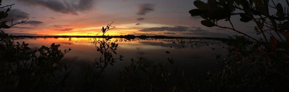
She was paddling fast with her toddler and baby swaddled as tight as possible in their deer skin blankets, the children stowed down in the boat, but placed towards the bow of the dugout canoe to keep the balance even from bow to stern. The water was gin clear, but only ankle-deep shallow, so the weight of the three together plus their supplies made for a tough go of paddling. The exposed mud bank to her east was the problem forcing her haste. The cool northerly breezes that preceded this week’s weather had dropped out, switching to stiff southeast, and exposing a vast mud flat. It only took a few days for the hatch of salt marsh mosquitos (Aedes taeniorhynchus) to become unbearable. The lack of winter rain and the return of southeast winds left the shore line muddy and dank. It was time, time to get off the beach and move back to the summer time ridges inland where many of her people will already be camped out. Such was life for the Ais people, migrating multiple times every year due to the changing meteorological tides, temps, and trade winds. Winters on or near the beach, summers on the sandy dry ridges to the west to get some respite from the swarms of proboscis equipped arthropods.
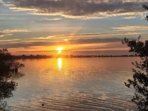
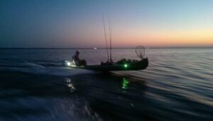
Paddling was easier now, having distanced herself from shore quite a bit, the ankle-deep sticky mud bottom gave way to an immense underwater pasture of submerged shoal grass (Halodule wrightii) that she paddled through with ease. The bugs were not present here in the middle of this mosquito lagoon, but she was concerned of what might be in store for her when she had to cross another strip of land to her northwest. How would she have known that, just a few weeks from now, in or around April of that year, Juan Ponce de Leon would set foot on the same beach she just spent her winter on? This will happen only 70 miles south from where she was today. Life for her people, and that lagoon would be forever changed. How would she have known that simply looking left, some 500 years later, private space programs would be launching rockets from the fabled launch pad 39a? That super structure that we see today when we paddle or push pole our boats while chasing ducks or looking for tailing redfish on this historic stretch of lagoon? It still seems to me as foreign now as the thought of it would’ve been to her. How would she have known that the water she paddled through that day, which teemed with life, life that sustained her people, would someday experience algal blooms, manatee deaths, and immense fish kills on an unprecedented scale as we read this now?

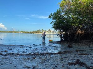
As she reaches the west side of the mosquito lagoon, she makes quick portage of a particular small isthmus of land. She knew exactly where to cross, a narrow flat ridge of land separating these two fabled bodies of water. Interconnected today, the mosquito lagoon and northern Indian river lagoon were separated from each other for thousands of years. 3 centuries after she crosses this bay with her canoe and kids, a canal will be cut just a few hundred yards north of where she finds herself pulling over. The pre-cut rolling logs and layered palmetto leaves make the pulling fairly easy but its warm today and the sweat and heat is becoming more tangible as she nears the other side. In her day, there was no Haulover Canal, there was no hydrologic connection to the northern Indian River Lagoon from the mosquito lagoon. For millennia these two water bodies were separate and different, and today they still have their subset of significant differences. Differences which matter when we talk about ecology and water quality. Jumping back into her canoe after her drag, with kids in tow and now repacked, she doesn’t pay attention to the shell midden to her south. The smell is foul, the clam (mercenaria spp.) shell pile is, essentially, the landfill of her time and it’ll still be a few weeks before the shells dry out and become, in essence, reduced to flat smooth rocks. It was time to resume her paddling.
She’s in different water now, different enough to know she’s closer to her camp, and a longer paddle was to come. The shoal grass is spotty here but the dense wigeon grass (Ruppia maritime) was a clear indicator that these two waters were uniquely separate. The headwaters of this river lay a few miles north, at present day Turnbull Creek, and they were some of her favorite spots to hunt, fish, and pick clams. It was also where her people grew crops due to the predictable irrigation sourced from the cool, clean, fresh water flowing in the creek. Thinking about crops made her hungry, but her favorite food was clams. She always liked clams more than oysters, clams were smooth and easy to foot around for, not sharp and prone to cut you when not paying attention to where you step. Simply throwing a few clams on some the smoldering coals of a fire made them open up with ease, and the sweet meat seemed to always satiate her. At one point, in the late 1900’s, Indian River clams would be renowned across the nation for their taste. She was getting hungry and thirsty now, while addressing the hunger would have to wait, she knew it was time to look for the manatees. As she paddled southwest aiming for a point of land where the river narrows, she kept her eyes studious of the waters ahead. Manatees, to her, were like a 500-pound rotund divining rod; find the manatees, she would find fresh water. She knew roughly about where the submerged spring would be, a spring that would roil an emerald green water directly into the lagoon, and sure enough, the smooth grey backs of several of the giants were seen on the horizon ahead of her. About 10 minutes of paddling later, with a quick dip of both hands into clear green water her thirst would be quenched.
The home stretch was now in reach. At about the present-day Nasa Causeway was the the tribe’s makeshift marina. It was a stretch of sandy beach with exposed coquina rock and and over hanging live oaks, where dozens of canoes were pulled upon the shore. A quick hike up the sand dunes to the east would put her back with her people. Nestled between beautiful “Rio De Ais” lagoon to the east as the Spanish named it, and the menacing marshes of the St. Johns River to the west this place would be home for the next 6 months. The sand ridge is still noticeable there today, and these weren’t the first humans to call this place home. Distant relatives, The Windover People, who predated her by 7000 years, also once dwelled in this land. This place offered protection from rival tribes and respite from the swarms of mosquitos that chased her off the beach earlier this day. It’s no wonder why the area has been occupied in some way shape or form for nearly 10,000 years.
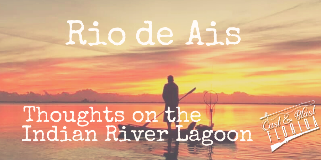
Her story is not unique, as it was a story that most likely could be shared by the many thousands of Amerindians that lived in “La Florida” before European contact. I can’t say that we or I know what her lagoon exactly looked like back then either, but we don’t have to imagine. We can use Jonathon Dickinson’s writings from 1696 during his time with these inhabitants to paint a picture of what this stretch of the lagoon was like. We can read the journals from the American merchants traveling south after Florida became a state in 1845. We can simply talk to our friends and family who lived here during the Apollo era of this place. While her story may not be unique, what is unique is the water she traversed. While the Indian River isn’t the only estuary in Florida, it is special and different, and it is important to understand that the Northern IRL is an ecosystem within an ecosystem. As such, the current ills of the lagoon today are also uniquely different than the problems that are faced on the lagoon’s southern stretches. Failure to recognize this cheapens the discussion when addressing how can we make things better.
The Timiquan, the Calusa, the Mayaca and the Jaega, and the Tequesta all had their water, that they loved as their own. Still today there is a human fidelity to the water that you “grew up” on. I don’t cry, I simply sigh when I hear about a fish kill or a brown tide bloom at this point in my life. Similar to when I worked in the local trauma department and ER, we become a type of “numb” to the bad stuff. However, I find myself more frustrated than ever when some “event” does happen, like our recent manatee die off, and the national media and talking heads all of a sudden care. “Where have you been” I think to myself? Internally, I become frustrated more with the lack of understanding of how this stretch of lagoon works and, what makes it uniquely what it is. Newsflash, our issues here aren’t “Big Sugar” and Lake Okeechobee discharges. This state, our home, “La Florida,” is different, with different issues throughout its peninsular landscape. This area “El Rio De Ais” as the Spanish called it, is a closed estuary with little to no tidal inputs. It is like an immense shallow aquarium that has its own distinctive issues. It’s a landscape and ecosystem that is worth saving.
 There is no catchy slogan or hashtag that can do that. We will never get back to what our Ais natives once enjoyed, but as recently as 2005 we had recovered a significant amount of seagrass that had died off during the point source discharge times of the 60’s through 80’s. Finally, we realized the folly of dumping untreated wastewater directly into our lagoon, yet it still took until the 1990’s for us to stop that practice. The northern IRL can recover if we fundamentally take care of the water. After our discontinuation of these “point” discharges, we actually recovered an immense amount of seagrass to the lagoon. At one point, in 2005 we recovered over 80 percent of the seagrass compared to a 1943 aerial assessment. These problems predate any recent changes to the Clean Water Act, the recent delisting of the manatee, and the decades long vilification of “Big Ag”. Yes, there are legacy issues in this stretch of lagoon, but the vast majority of these issues stem, simply put, from our existence here. I am the problem, because I live here. Our problems are not from a dairy in Arcadia, a sugar farm in Clewiston, or aquatic plant management in Lake Okeechobee. They’re not due to the “Savings Clause” or Lake Okeechobee water levels. We have an anthropogenic nutrient enrichment issue stemming from years of storm water and waste water inputs surpassing the ecosystems capacity to handle said inputs. There is no debate on this matter. Tagging on the details of who is to blame is pointless because it is not addressing or fixing root causes.
We are all the problem.
I’m asking anyone who reads this to please show this area the respect it deserves. “Send it South” doesn’t save the manatees in Merritt Island or Titusville. Blaming an agency or water management district that doesn’t have jurisdiction of our county’s water only serves to obfuscate and minimize the potential for fundamental positive change. These creatures, this water . . . Water that you say you want to save – it needs uniquely calculated and fundamental long-term fixes. The undeniable reality for this area is that decades long human storm and wastewater issues are the root cause of the northern IRL’s collapse. If you want to help, start with respecting the nuance that comes with managing Florida’s water landscape from Pensacola to Key West. Each watershed has its own distinct issues. Just like the people before us, their own unique cultures were tied to the waters that they made their homes. If a solution today sounds like it’s an easy fix, it’s probably not the right cause to support. “Stop the Spray”, “Send it South”, “Restore the Flow” or any other catchy slogan is uniquely stated to catch people’s support but does little to tell the true story or make a fundamental change. Please take the time to dig a little deeper, listen before you speak, and fight the echo chamber of simple solution conservation.
We can do this but not if we choose the easy way.